Tuesday, 10 May 2016

Syrian Refugees will boost Canada's econamy

http://www.huffingtonpost.ca/2015/11/26/refugees-economy-canada_n_8658076.html

Syrian Refugees will boost Canada's economy

syrian refugees


The article's main thesis states that actual fact states the benefits outway the cost for Canada to be taking in refugees, in actual sense Canada needs them and their statistics of high birth rate E.G. We need workers.


Importantly is Canada’s aging workforce all over the country. The article sites Atlantic Canada which in fact continues to age without workforce replenishment in less than a decade there would be a serious population crisis. The refugees offer the perfect solution to their problems by supplying work willing young people to fuel and drive the economy of Canada's future.

Statistical Data sourcing and details can be found by clicking the link.

Open The Doors

Matthew.K

To sum up the article I chose, Canada response to the syrian Refugees is very positive and believe that everything is going to go smoothly. The communities response is different tho people are worried about people taking their jobs away and there homes. If you think about it lots of people are coming in to canada so it is possible. The government says some of them are going start their own businesses so there are going to be more jobs available.          


http://www.international.gc.ca/development-developpement/humanitarian_response-situations_crises/syria-syrie.aspx?lang=eng

Is there enough resources for the Syrian Refugees?

Canadians were asked if they think communities have enough resources for the Syrian Refugees. The total of the poll of people who think there is not enough resources for the Syrian Refugees is 61% and the rest of the 33% agreed there is enough. This could just be a few communities but this is still a problem that can affect the settlement of the Syrian Refugees. Syrian Refugees need settlement services such as a home, language classes, food services, clothes, etc. Without all of this services, it will be difficult to communicate and help them. This problem can also slow down the settlement of the refugees in the future.Syrian refugees Rahaf, second left, and her brother Ramez, centre, get new winter clothing at Pearson International Airport in Toronto on Monday, February 29, 2016. (Nathan Denette/THE CANADIAN PRESS)

Not enough resources for syrian refugees

the article talks about how we let in 27k refugees but we don't have enough resources to support them because most of them had health issues, it costs a lot of money to build places for them to stay,etc

Monday, 9 May 2016

Sinking of the RMS Titanic.

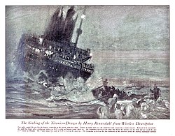
The sinking of the RMS Titanic occurred on the night of 14 April through to the morning of 15 April 1912 in the north Atlantic Ocean, four days into the ship's maiden voyage from Southampton to New York City. The largest passenger liner in service at the time,Titanic had an estimated 2,224 people on board when she struck an iceberg at around 23:40 (ship's time) on Sunday, 14 April 1912. Her sinking two hours and forty minutes later at 02:20 (05:18 GMT) on 15 April resulted in the deaths of more than 1,500 people, which made it one of the deadliest peacetime maritime disasters in history.
Titanic received six warnings of sea ice on 14 April but was travelling near her maximum speed when her lookouts sighted the iceberg. Unable to turn quickly enough, the ship suffered a glancing blow that buckled her starboard (right) side and opened five of her sixteen compartments to the sea. Titanic had been designed to stay afloat with four of her forward compartments flooded but not more, and the crew soon realized
 that the ship would sink. They used distress flares and radio (wireless) messages to attract help as the passengers were put into lifeboats. In accordance with existing practice, Titanic's lifeboat system was designed to ferry passengers to nearby rescue vessels, not to hold everyone on board simultaneously. So with the ship sinking fast and help still hours away, there was no safe refuge for many of the passengers and crew. Compounding this, poor management of the evacuation meant many boats were launched before they were totally full.
Titanic sank with over a thousand passengers and crew still on board. Almost all those who jumped or fell into the water drowned within minutes due to the effects of hypothermiaRMS Carpathian later arrived on the scene about an hour and a half after the sinking and had rescued the last of the survivors by 09:15 on 15 April, some nine and a half hours after the collision. The disaster caused widespread outrage over the lack of lifeboats, lax regulations, and the unequal treatment of the three passenger classes during the evacuation. Subsequent inquiries recommended sweeping changes to maritime regulations, leading to the establishment in 1914 of the International Convention for the Safety of Life at Sea (SOLAS), which still governs maritime safety today. The number of casualties of the sinking is unclear, due to a number of factors, including confusion over the passenger list, which included some names of people who cancelled their trip at the last minute, and the fact that several passengers traveled under aliases for various reasons and were double-counted on the casualty lists. The death toll has been put at between 1,490 and 1,635 people. The figures below are from the British Board of Trade report on the disaster.

1887 Nanaimo mine explosion

The Nanaimo mine explosion on May 3, 1887, in NanaimoBritish Columbia killed 150 miners. Only seven miners survived and the mine burned for one full day. The explosion started deep underground in the Number One Coal Mine, after explosives were laid improperly. Although many miners died instantly, others were trapped by the explosion. These men wrote farewell messages in the dust of their shovels. Nearly 150 children lost their fathers and 46 women became widows. A plaque at the foot of Milton Street commemorates the event.
Although past documents put the death toll at 148,
researchers have since revised the number to 150, including 53 Chinese workers. Chinese workers were listed in the government inquest and annual report of the Minister of Mines as "China men, names unknown", followed by a tag number. B.C. employers did not have to report the deaths of Chinese employees until 1897. Some accounts suggest that 48 of the 53 miners had the surname of Maj — records may have been destroyed when Nanaimo's Chinatown burned to the ground in 1960. The monument on Milton Street lists the names of white miners, but only the tally number for Chinese miners, who were blamed by many white Nanaimoites for the disaster, claiming they could not read signs or instructions.
Operated by the Vancouver Coal Company, the Number One mine opened in 1884 at the foot of Milton Street in Nanaimo. Its shafts and tunnels extended under the harbor to Protection Island, Newcastle Island, and the Nanaimo River. After the explosion, the mine re-opened, and produced 18 million tons of coal before permanently closing in 1938.

           1946 Vancouver Island Earthquake.

The 1946 Vancouver Island earthquake occurred with a moment magnitude of 7.3 that struck Vancouver Island, on the Coast of British ColumbiaCanada, at 10:15 a.m. on Sunday, June 23. The main shock epicenter occurred in the Forbidden Plateau area northwest of Courtesan. While most of the large earthquakes in the Vancouver area occur at tectonic plate boundaries, the 1946 Vancouver Island earthquake was a crustal event. Shaking was felt from Portland, Oregon to Prince Rupert, British Columbia. This is one of the most damaging earthquakes in the history of British Columbia, but damage was restricted because there were no heavily populated areas near the epicenter, where severe shaking occurred.
This earthquake is Canada's largest historic onshore earthquake. However, the greatest earthquake in Canadian history recorded by somersetted was the 1949 Queen Charlotte earthquake, an interpolate earthquake that occurred on the ocean bottom just off the rugged coast of Graham Island, which reached magnitude 8.1 on the moment magnitude scaleThe tectonics that caused the 1946 Vancouver Island earthquake are poorly known. No surface expression of the offset was noticed, most likely because the epicenter area is very remote and densely forested. A comprehensive examination and computer interpretation of seismic data from over 50 stations has shown that a possible explanation of the earthquake includes a strike-slip fault corresponding to the lengthy axis of Vancouver Island, known as the Beaufort Range Fault. A fault running across Vancouver Island, corresponding to the projection of the underwater. Nootka Fault on the British Columbia Coast, is also a possibility but an unlikely one because the earthquake no evidence of offsets along a series of highways that follows much of the eastern coastline of Vancouver Island, called Island Highway, and other roads between Courtesan and Campbell River. The estimated depth of the earthquake places it within the continental crust, not at the margin with the Cascades subduction zone, and certainly not inside the subduction zone itself. Specifically, the earthquake's epicenter was positioned somewhere in the Forbidden Plateau region, in central Vancouver IslandThough very destructive, the earthquake caused only two casualties: Jacob L. Kingston, aged 69, and Daniel Idler, who was 50. Kingston suffered a heart attack, while Idler drowned when his dinghy was swamped by a wave.

In Vancouver, damage consisted of lofty buildings oscillating violently, and a piece of masonry fell from the local railway station. In addition, within the city, at least one gas line cracked and several power outages occurred. Fires broke out in several chimneys, and at least one swing-span bridge was fractured by the shaking. In the Hotel Vancouver, which housed the elderly and caught on fire, more than 500 war veterans' families fled the flames. One writer, George Finley, stated that the Lions' Gate Bridge "swayed like a leaf", coinciding with a "low, rumbling sound, like a deep growl." The 1946 Vancouver Island earthquake demolished 75% of the chimneys in the communities of Cumberland, Union Bay, and Courtenay and caused extensive damage in Comox, Port Alberni, and Powell River, on the eastern side of the Strait of Georgia. Some chimneys were fractured in Victoria, and people in Victoria and Vancouver experienced great fright, with some seen fleeing into the streets.
Landslides created by the earthquake were common throughout Vancouver Island. Land subsidence resulted from the earthquake, most commonly around shorelines on the Strait of Georgia. This included the bottom of Deep Bay which sank between 2.7 m (9 ft) and 25.6 m (84 ft). These measurements were reported by the Canadian Hydrographic Service. Also, a 3-metre (9.8 ft) ground shift occurred on Read Island. Ships throughout the region were affected, and those on board them during the earthquake described it as similar to having run over a sand bar or striking a rock. Undersea power lines were destroyed in the long narrow Alberni Inlet and near the city of Powell River. All lighthouse keepers in the surrounding area felt the earthquake, and experienced damages including shattered windows and smashed dishes. A tsunami struck the west coast of Texada Island with two waves, the first being 2 metres (6 ft 7 in) high and the second 1 metre (3 ft 3 in) high. The earthquake caused a landslide near Mount Colonel Foster. One fortunate occurrence allowed researchers afterward to review the effects of the earthquake: an aerial photographic survey of Vancouver Island had commenced in 1946, soon after the earthquake, and these photographs were eventually studied by a geoscientist in the late 1970s.
South of the Canada–United States border in Washington State, some chimneys fell at East sound on Oscar Island and a concrete mill was damaged at Port Angeles. In Seattle, some damage occurred on upper floors of tall buildings, and one bridge was damaged. The shock was strongly felt at Bellingham, Olympia,Raymond, and Tacoma. The earthquake was powerful enough to knock the needle off a seismograph at the University of Washington, and was sustained for about a minute even in Seattle.
The earthquake caused somewhat astounding movement among structures, moving one 300-foot (91 m) wall about 35 feet (11 m) and caused one home to shift for 5 feet (1.5 m) off its foundation. The total affected area in Canada and the United States was about 260,000 km2 (100,000 sq mi).